

Oil exploration is a method to find a potential trap which contains hydrocarbon. The following four (4) geological factors have to be present for the existence of an oil or gas trap.
- Source Rock – Hydrocarbons are formed when organic rick rock is subject to high pressure and temperature over an extended period of time.
- Migration – The hydrocarbons are expelled from source rock by density related mechanisms. The less dense hydrocarbons causes overpressure, lighter hydrocarbons migrate due to buoyancy and fluids expand due to increased heating from burial. Most hydrocarbons migrate to surface as oil seeps, but some will get trapped.
- Reservoir Rock – Hydrocarbons are contained in a reservoir rock. This is commonly a porous sandstone or limestone. The reservoir rocks must also be permeable so that the hydrocarbons will flow to surface during production.
- Trap – The permeable reservoir rock covered by some low or impermeable cap rock (shale) is referred to as trap. The trap prevents migration of hydrocarbons up through the reservoir rock.
There are two main groups of traps namely structural and stratigraphic
Structural Traps are types that form as a result of some structural deformation – a bend or dip of rock. The deformation tends to take place over millions of years. The various types of structural traps include Anticline, Fault and Salt domes. Anticline traps are formed by folding of rock due to sideways pressure, Fault traps are formed when reservoir rock is split along a fault line and salt dome traps are formed as a result of below ground salt (denser than rock) moving upwards slowly
Stratigraphic traps are formed as a result of the deposition in sedimentary rocks. There are basically two types of stratigraphic traps primary and secondary. Primary stratigrpahic traps are structural changes due to discontinuous deposition of sediment during the sedimentation process. Secondary stratigraphic traps result from changes that develop after sedimentation has occurred which includes changes in porosity of the rock that lead to formation of a cap like rock.
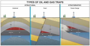
Image Source: http://www.wsgs.wyo.gov/
GEO-PHYSICAL SURVEY
After selecting the area of interest, prior to drilling exploratory wells various types of geo physical surveys are conducted and measurements performed to obtain information on the subsurface formations. The most common methods used include the following:-
Magentometric Surveys: This survey is done aerially from aircraft using magnetometer to measure variations in the earth’s magnetic field in order to locate sedimentary rock formations. The sedimentary rocks have low magnetic properties than other rocks.
Aerial Photogrammetric Surveys: done by taking photographs with special cameras from air craft provides three dimensional views of the earths subsurface to determine potential oil and gas deposits.
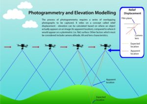 Image Source: http://www.remoteaerialsurveys.co.uk/
Gravimetric Surveys: measures variations in earth’s magnetic field caused by density difference of sub surface rocks. The minute differences in gravity provide information regarding underlying formations.
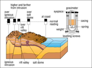
Image source: http://www.eo-miners.eu/
Magnetic Surveys: measures strength or intensity of earth’s magnetic field. Magnetic survey and Gravimetric Survey is passive method of survey and is widely used during pre-drilling phase.
Seismic Surveys: is an active survey used during both pre-drilling and development phases. Seismic survey measurements are obtained from induced shock waves generated through a small diameter hole. The waves reflected from the sub strata are received in special devices. The elapsed time between the beginning of shock wave and the return of the echo is used to determine the general characteristics of the subsurface structure.
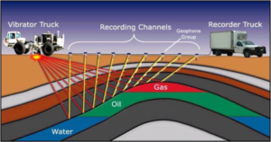
Image Source:http://cougarlandservices.net/
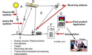
Remote Sensing:Solar radiation from the Earth’s surface varies in intensity and frequency depending on the sub-surface property. This observation is collected via satellite to predict the sub-surface structure. In order to image the sub-surface structure, historical geological data collected previously by gravimetric, magnetometric, and seismic surveys are used. The fi nal image is obtained by geological imaging software (GIS).
ROLE OF GEOSCIENTISTS
The majority of geoscientists employed in oil and gas field fall in to one of the three sub specialties.
Geologists – understands the rock. Structural geologists provide an understanding of subsurface deformation processes that can create hydrocarbon traps. Strati-graphers recognize and follow rock beds or layers from one well to another. The act of going from area whose beds and rock layers are known to an unknown area but assumed to be similar is called stratigraphic correlation. This is important to understand the geometry, size and lateral continuity of potential oil and gas traps, reservoirs and seals.
Geophysicists – interprets the subsurface structure or configuration through gravimetric, magnetic or seismic surveys. Try to predict where oil and gas occur by “remote sensing” using gravity, magnetic or seismic surveys and geo physical imaging tools to gather data on subsurface characteristics. The data generated are typically processed through computers to build 3 dimensional models to visualize and understand the image of subsurface.
Geochemists – studies the chemistry of petroleum and its sources to characterize the petroleum type. They also develop input in to basis modeling which is developed to provide quantitative petroleum system models including source, reservoir, seal, trapping mechanism and hydrocarbon charge.
For more information and introduction to petroleum geology including information on sedimentary rocks, porosity, permeability, oil and gas traps, prospecting, etc please visit http://www.geomore.com/
Source of Information:-
- Wikipedia: https://en.wikipedia.org/
- Energy Canada: http://energyeducation.ca/
- Methods of Exploration and Production of Petroleum Resources By Ione L. Taylor U.S. Geological Survey, Reston, Virginia, USA