
The very large volume of information and data collected from the various geo physical & geo logical surveys and exploratory wells are used to prepare various types of map viz., Contour maps, Isopach maps. Contour maps are lines drawn at regular intervals of depth to show the geologic structure relative points called the correlation markers. Other maps such as porosity map, permeability map and maps showing variations in rock characteristics are also produced. With all the data and formation maps, conceptual models describing the details of the structure and the location of the oil and gas within the structure are prepared. The data available at this stage is sufficient to estimate the reserves and develop a plan for the development of the field for commercial operation.
PRE DRILLING PHASE
Prior to drilling a well, a geologic target (end point of the well) is identified by geoscientist to meet the objective of various wells viz., production well, injection well, gas lift well, etc. The target will be matched with a surface location (starting point of the well) to design a trajectory between the start and end points identified.
When the well path is identified, geoscientist and engineers develop a set of presumed properties (pore pressure, fracture gradient, well bore stability, porosity, permeability, lithology, faults and clay content) of the subsurface that will be drilled through to reach the target. The is set of presumptions shall be used by well engineers to perform the casing and completion design for the well. Further detailed planning like drill bit selection, bottom hole assembly, drilling fluid are carried out and step by step method statements are written to provide instruction for executing the well drilling in a safe and cost efficient manner.
DRILLING
The well is created by drilling a hole 12 cm to 1 meter (5 in to 40 in) in diameter into the earth with a drilling rig that rotates a drill string with a bit attached. After the hole is drilled, sections of steel pipe (casing), slightly smaller in diameter than the borehole, are placed in the hole. Cement may be placed between the outside of the casing and the borehole known as the annulus. The casing provides structural integrity to the newly drilled wellbore, in addition to isolating potentially dangerous high pressure zones from each other and from the surface.
With these zones safely isolated and the formation protected by the casing, the well can be drilled deeper (into potentially more-unstable and violent formations) with a smaller bit, and also cased with a smaller size casing. Modern wells often have two to five sets of subsequently smaller hole sizes drilled inside one another, each cemented with casing. Mud log in process, is a common way to study the lithology when drilling is being executed.
The type of wells that are drilled in the oil and gas industry are classified as follows:-
| NO. | TYPE | DESCRIPTION |
|---|---|---|
| A. | BY PRODUCTION | |
| 1 | Oil wells | Wells that produce only oil. |
| 2 | Associated Gas wells | Natural gas is almost always a byproduct of producing oil. |
| 3 | Gas wells | Wells that produce only natural gas. |
| B. | BY LOCATION | |
| 1 | Onshore | Targets a reservoir underneath the land. |
| 2 | Offshore | Targets a reservoir underneath an ocean |
| C. | BY PURPOSE | |
| 1 | Wildcat wells | Drilled where little or no known geological information is available. |
| 2 | Exploration wells | Drilled purely for exploratory (information gathering) purposes in a new area, usually based on seismic data, satellite surveys etc. |
| 3 | Appraisal wells | Used to assess characteristics (such as flow rate, reserve quantity) of a proven hydrocarbon accumulation, purpose is to reduce uncertainity. |
| 4 | Production wells | Drilled primarily for producing oil or gas, once the producing structure and characteristics are determined. |
| 5 | Development wells | Drilled for the production of oil or gas already proven by appraisal drilling to be suitable for exploitation. |
| 6 | Service wells | Used for fishing and wire-line operations, packer/plug placement or removal and reworking. Service wells are also drilled for underground disposal of salt water |
| 7 | Abandoned wells | Permanently plugged in the drilling phase for technical reasons. |
| D. | BY ACTIVE WELLS | |
| 1 | Oil Producers | Producing predominantly liquid hydrocarbons, but mostly with some associated gas. |
| 2 | Gas Producers | Producing almost entirely gaseous hydrocarbons. |
| 3 | Geothermal wells | Producing extremely high-pressure (7,000 psi) and high-temperature (149 °C) water which may contain hydrocarbons. The water becomes a rapidly expanding cloud of hot steam and vapours upon release to the atmosphere from a leak or rupture. |
| 4 | Stripper wells | Producing less than ten barrels of oil a day from a reservoir |
| 5 | Water Injectors | Injecting water into the formation to maintain reservoir pressure. |
| 6 | Disposal wells | To dispose of produced water in to the fresh water resource |
| 7 | Acquifier Producers | Intentionally producing water for re-injection to manage pressure. If possible this water will come from the reservoir itself. |
| 8 | Gas Injectors | Injecting gas into the reservoir often as a means of disposal or sequestering for later production, but also to maintain reservoir pressure. |
| E. | BY LAHEE CLASSIFICATION | |
| 1 | New Field Widcat (NFW) | Far from other producing fields and on a structure that has not previously produced. |
| 2 | New Pool Wildcat (NPW) | New pools on already producing structure. |
| 3 | Deeper Pool Test (DPT) | On already producing structure and pool, but on a deeper pay zone. |
| 4 | Shallower Pool Test (SPT) | On already producing structure and pool, but on a shallower pay zone. |
| 5 | Outpost (OUT) | Usually two or more locations from nearest productive area. |
| 6 | Development Well (DEV) | Can be on the extension of a pay zone, or between existing wells ( Infill ). |
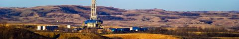
DRILLING RIG
The drilling operation is performed using huge and complex equipment known as DRILLING RIG which contains all necessary equipment to carry out drilling in a safe manner. The most commonly used drilling method for oil and gas well drilling is ROTARY DRILLING METHOD. The rotary drilling rigs are used both in onshore as well as offshore.
The offshore drilling rigs are further classified as floating and bottom support types. The floating type rigs include semisubmersible and drill ship. The bottom support types include platform, barge and jackup rigs.
Land drilling rigs include Conventional, Jacknife and Portable mast. The land drilling rigs are further classified in to different sizes based on the drilling depth.
- Light Duty Rigs: Drill holes from about 1000 to 1500 m
- Medium Duty Rigs: Drill holes ranging from 1200 to 3000 m
- Heavy Duty Rigs: Drill holes from about 3500 to 5000 m
- Ultraheavy Duty Rigs: Drill holes from about 5500 to 7500 m
A typical drilling rig including the components is are depicted in the below picture.

COST OF DRILLING
The cost of a well depends mainly on the daily rate of the drilling rig, the extra services required to drill the well, the duration of the well program (including downtime and weather time), and the remoteness of the location (logistic supply costs). Onshore wells can be considerably cheaper, particularly if the field is at a shallow depth, where costs range from less than $1 million to $15 million for deep and difficult wells.
The total cost of an oil well mentioned does not include the costs associated with the risk of explosion and leakage of oil. Those costs include the cost of protecting against such disasters, the cost of the cleanup effort, and the hard-to-calculate cost of damage to the company’s image.
Information Sources
Wikipedia: https://en.wikipedia.org/